Your Smoky Mountain Rafting adventure can be even more of a thrill when you add in a side trip to nearby Max Patch in the Pisgah National Forest. Max Patch is a gem so special and so rare that we almost hesitated to share it for fear of overcrowding this wonderful place. We’re all about all things outdoors at Rafting in the Smokies, and we think you’re special enough to let in on this little secret spot on the famed Appalachian Trail.
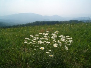
What makes Max Patch so special? For starters, on a clear day, it’s by far one of the best 360 degree views of the Great Smoky Mountains to the south, the Unakas to the north, and the Black Mountains and Great Balsams to the southeast. The summit of Max Patch at 4629’ offers one-of-a-kind views of the regional landscape that includes almost forty other mountaintops over 6,000’. It’s like viewing a sea of mountains…a simply spectacular vantage point! Secondly, if it’s not a clear day, you’ll still enjoy the uniqueness of the 300+ acre grassy bald. Think The Sound of Music and you’re there! Max Patch was first cleared in the 1800’s for pasture for livestock. In the 1920’s the bald was used as a landing strip for tourist planes. If the National Forest Service did not maintain the peak, it would soon grow back into a forest. Another great thing about Max Patch is it’s only about a 1.5 mile walk from the parking area to reach the summit making it easily accessible for young and old alike. We strongly suggest following the loop trail to the left to the summit, in a clockwise direction, and then hike down the steeper part of the trail back to the parking area. On a recent hike up the loop trail, the native flame azaleas were at peak and an amazing site. The blackberries and blueberries were coming on, so there will be an extra treat for those hiking in July.
How to get to Max Patch from Rafting in the Smokies:
Follow I-40 east toward Asheville, into North Carolina and through the tunnel. 2 miles past the tunnel is your Exit 7 – Harmon Den. After exiting, turn left onto Cold Springs Creek Road. The road turns to gravel as you enter the Pisgah National Forest. (Please note this is a winding mountain road and narrow in some places so we do not recommend taking a motor home or camper trailer on this road.) There should be several brown Forest Service signs directing you, but if you come to a fork about 6 miles in, just keep left. Go approximately 2 more miles and you’ll see the small parking area on your right. It’s only 8 total miles in, but the winding road makes it seem much further drive.


